Instructions
User manual concerning INTERACT GIS
Tomas Thierfelder; Swedish University of Agricultural Sciences SLU, Uppsala Sweden Britta Löfvenberg; UmU ITS, Umeå University, Sweden Anders Printz, UmU ITS, Umeå University, Sweden
- Summary
- Introduction
- Connecting your station with INTERACT GIS
- Applying for visits at Arctic stations with INTERACT GIS
- Operative costs of INTERACT GIS
- Processing of personal data in INTERACT GIS
- The longevity of INTERACT GIS
- Contact information and system support
Role definitions with usage examples
The tool has the following roles that have specific main responsibilities in the process.
- Public access An unregistered user may apply to visit at a station, browse the station catalogue, view research project information for the stations and list publications connected to the stations.
- Principal investigator Creates project, course/education or conference/workshop. Apply for visit at a station.
Summary
This document provides information that will enable potential users of INTERACT GIS to enter the system at the various user-levels that are supported. Once the users have entered INTERACT GIS, it is quite self-explanatory provided that they invest in taking the personal time required to learn the depths of the system. This document will be disseminated via INTERACT GIS, and may be found under its menu “Instructions” together with an interactive on-line tutorial. In combination with the “INTERACT GIS declaration regarding the processing of personal data”, which also may be found onboard the system, these documents constitute a manual for how to enter, use, and understand INTERACT GIS.
Contact information regarding general support in the process of entering and using INTERACT GIS is provided within the system itself.
Introduction
Dear potential users of INTERACT GIS,
After having put considerable resources and efforts into developing INTERACT GIS, the system is now available for your usage at www.interact-gis.org. INTERACT GIS has been developed into a rather deep set of functionalities that are available at a number of different levels of privilege, ranging from free public usage, through levels of administrating field stations, visiting scholars, and activities performed at field stations, to the top level of administrating INTERACT GIS itself. As part of the development effort, the operative platform has been changed into the latest available technology, facilitating INTERACT GIS to operate in accordance with EU’s General Data Protection Regulation (GDPR) safety standards at a very effective level of costs.
Once you have entered INTERACT GIS, it is quite self-explanatory if you only invest in taking the personal time required to learn the depths of the system. In order to enter INTERACT GIS, and to boost your understanding of what you are facing, you need to know the following: INTERACT GIS is now hosting the digital version of the INTERACT Station Catalogue, which already has been fed into the system. In addition, the Station Catalogue will be supplemented with information regarding the monitoring activities that are being performed as part of regular station activities. One new thing with INTERACT GIS (as compared with earlier versions) is that all the information mentioned above is available for edition by the stations themselves. In fact, all user field-stations are encouraged to build and maintain their respective station-records as part of their everyday work.
Connecting your station with INTERACT GIS
To start using INTERACT GIS, you need to pass three consecutive steps in order to safely acquire the fundamental system privilege of representing a station (all concepts will be explained further down the document):
- First you simply need to visit www.interact-gis.org as a public user, and assign for an account using the Sign-up menu available at the upper-right corner of the user interface.
- Thereafter you need to apply for station privileges with an “official” email to interact-gis@slu.se, wherein you prove who you are and what station you are representing.
- Finally, you digitally sign a GDPR Data Processing Agreement with the Swedish University of Agricultural Sciences SLU who is the legal “processor partner” of your station.
As a fully connected station, you will be able to share catalogue information with any public user. The public user will be presented with a rich array of filtering functionalities that enables an interactive search for stations that fulfil multiple criteria relevant to Arctic research and monitoring activities. And if occasional users happen to visit INTERACT GIS, the system may be used for studies and/or for the sheer fun of enjoying the digital Station Catalogue. At the “Catalogue level of usage”, no personal information is processed and no operational costs are charged.
Applying for visits at Arctic stations with INTERACT GIS
The INTERACT GIS Sign-up menu may also be used for assigning a PI-account to any public user, which will facilitate for PI’s to apply for permission to visit and perform activities at field-stations (perhaps after having identified a suitable station based on catalogue information). Receiving and administrating PI-applications require stations to enter “Active level of usage” in INTERACT GIS, which may be easily switched on and off once the station is fully connected. If a station is switched off from active user-mode, it won’t be visible for applicant PI’s. At the active level of usage, stations start to accumulate information regarding activities related to research, monitoring, conferencing, and educational activities, including personal information regarding visitors that is highly liable to GDPR. Hence, in active usage, personal information is processed and operational costs are charged.
In active usage, INTERACT GIS is designed to provide far-reaching support regarding the general administration of field-stations. Based on the information provided by the applications of PI’s, anything from physical resources to publication databases may be planned ahead of the field-season, and the resulting database contents may be assessed for annual reports etc. Based on the experience of already having had former versions of INTERACT GIS in active service for a number of years, the cost-efficacy with which field-stations may be managed will most likely be boosted by the active usage of INTERACT GIS. This economic gain is likely to significantly exceed the minor operational costs charged to active user stations. With active stations storing their administrative data in the shared INTERACT GIS database, a record encompassing all user stations is cumulating over time. In addition, most stations have already contributed to the database with historic activity records. Such a cumulated record has invaluable properties that range from providing data to future historians, to enabling a collaboratively regulated monitoring effort across the Arctic.
At the PI level of privilege, scholars accumulate a personal editable record of applications, activities, and collaborators across their respective networks of visited stations. In the new version of INTERACT GIS, a “project” may consist of any number of activities spread across any number of stations. The project is hence at focus, where former versions focused on “stations”. Just like stations are encouraged to embrace the administrative functionalities available at the active level of usage, PI’s are encouraged to include the maintenance of their respective INTERACT GIS records as part of everyday work.
With the bilateral correspondence between PI’s and field-stations being semi-automated by INTERACT GIS, the system supports collaborative communication between stations and visitors already from the application phase, while maintaining a boosted level of administrative cost-efficacy.
Operative costs of INTERACT GIS
The operative costs of INTERACT GIS are currently around 1,800 Euros per year, which are evenly split across the stations that use the system in active mode. If thirty stations use INTERACT GIS in active mode, this would amount to 60 Euros per station and year. If, say, 60 stations would use the system actively, the annual fee would reduce to 30 Euros which is approaching free usage. In other words, the annual fee per station may be reduced by solidarity policies of the users themselves. The annual fee will be annually charged, starting exactly one year after stations have switched on Active mode. This will provide a one-year test period whereunder stations may switch off Active mode as they like. After the test period, stations must settle for their desired level of usage, and will be charged thereafter. The administration of operational costs will be delegated to the INTERACT GIS management board wherein active user stations will be represented together with system operators and system owners.
Processing of personal data in INTERACT GIS
A central aspect of INTERACT GIS involves collecting and storing personal data that falls within the framework of the European Parliament’s General Data Protection Regulation, GDPR. Such collection and storage require a controller, which according to the GDPR is “the legal person that processes personal data within its business”. As INTERACT GIS offers support to the field stations’ own operations, each station that uses the system is therefore to be considered a controller. In the event that the controller’s organisation engages an external resource to process their personal data, this resource is called a “processor”. In the case of INTERACT GIS, it is the Swedish University of Agricultural Science, SLU, that is responsible for the processing of personal data on behalf of the field stations until further notice. According to direct requirements of the GDPR, the relationship between a controller and processor must be regulated in a written Data Processing Agreement (DPA) wherein the processor’s responsibilities are clarified:
- The processor assumes responsibility for ensuring an adequate level of security in terms of aspects such as technical and organisational security, data availability, authorisation, etc.
- The processor assumes responsibility for immediately notifying the controller of any breaches, incidents, or doubts regarding the application of the Personal Data Act.
In its role as processor, SLU delegates the responsibility for operation and service of INTERACT GIS to its sub-processor “ICT Services and System Development” at Umeå University Sweden, UmU ITS. This delegation must be regulated in a written Data Sub-processing Agreement.
As a result of the above GDPR requirements, the INTERACT GIS DPA must be digitally signed by every individual field station that uses INTERACT GIS in active mode. However, since stations have the free choice of switching active mode on and off, all stations that connect with INTERACT GIS must sign a DPA in case they wish to switch on to active mode. All digitally signed DPA’s will be physically stored at SLU.
The INTERACT GIS DPA may be downloaded directly from INTERACT GIS, where it is found under the
GDPR menu (“INTERACT GIS declaration regarding the processing of personal data”). The INTERACT GIS DPA also contains information regarding the structure and usage of INTERACT GIS that may add valuable information to the above instructions.
The longevity of INTERACT GIS
INTERACT GIS is designed for independent autonomy with respect to time-limited projects such as INTERACT and SITES. An important part of system development is the design of an autonomous management board where users, operators, developers, and intellectual owners cooperatively take full responsibility for the longevity of the system. Principally, INTERACT GIS is designed to operate towards a forever horizon.
SLU owns the intellectual properties of INTERACT GIS.
Contact information
- For issues concerning the connection of your station with INTERACT GIS, contact interact-gis@slu.se.
- For issues concerning the signing-up as a PI user with INTERACT GIS, see on-line information.
- For issues concerning general system support, please use the contact form found here
Public access
An unregistered user may apply to visit at a station, browse the station catalogue, view research project information for the stations and list publications connected to the stations.
The application process is accessed here and is requires that a project/course or conference/worshop already has been created. To create any of these, you must first register a user in the system. This can be done here. When a user is registered, you are free to create an activity connected to one, or in the case of a project, one or more stations. Please be aware that the activity is not considered approved/active for any given station until an application for the activity has been recieved and approved for the station.
Principal investigator, PI
Principal investigator, PI, have the rights to create projects, courses/educations and conferences/workshops.
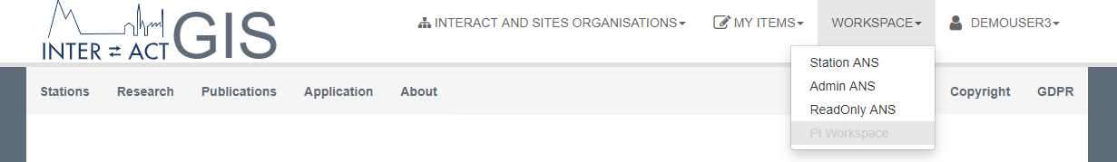
If you have more than one role, you will see the workspace-swicher. Either on the top of the site next to your username or in the "Menu"-button depending on the size of the screen the device you access the site has. You can select a role by clicking on "Workspace" and choose the role you want to act like. The role you currently have is marked with a gray background color. Note, the menu entries will change depending on the role you select.
My items
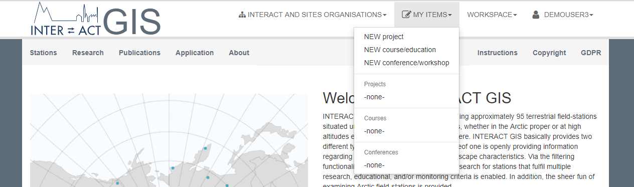
PI:s has a special menu for handling old projects, conferences or courses, or to create new entries you can do it all by clicking on "My items" at the top. Everything you as a PI want to do can be found in "My items". Here you can create new projects, conferences or courses but you can also access your old projects, conferences and courses in the dropdown menu.
Create a new project
To create a new project you have to access "NEW project" in the My items"-menu. All fields marked with a * is mandatory.
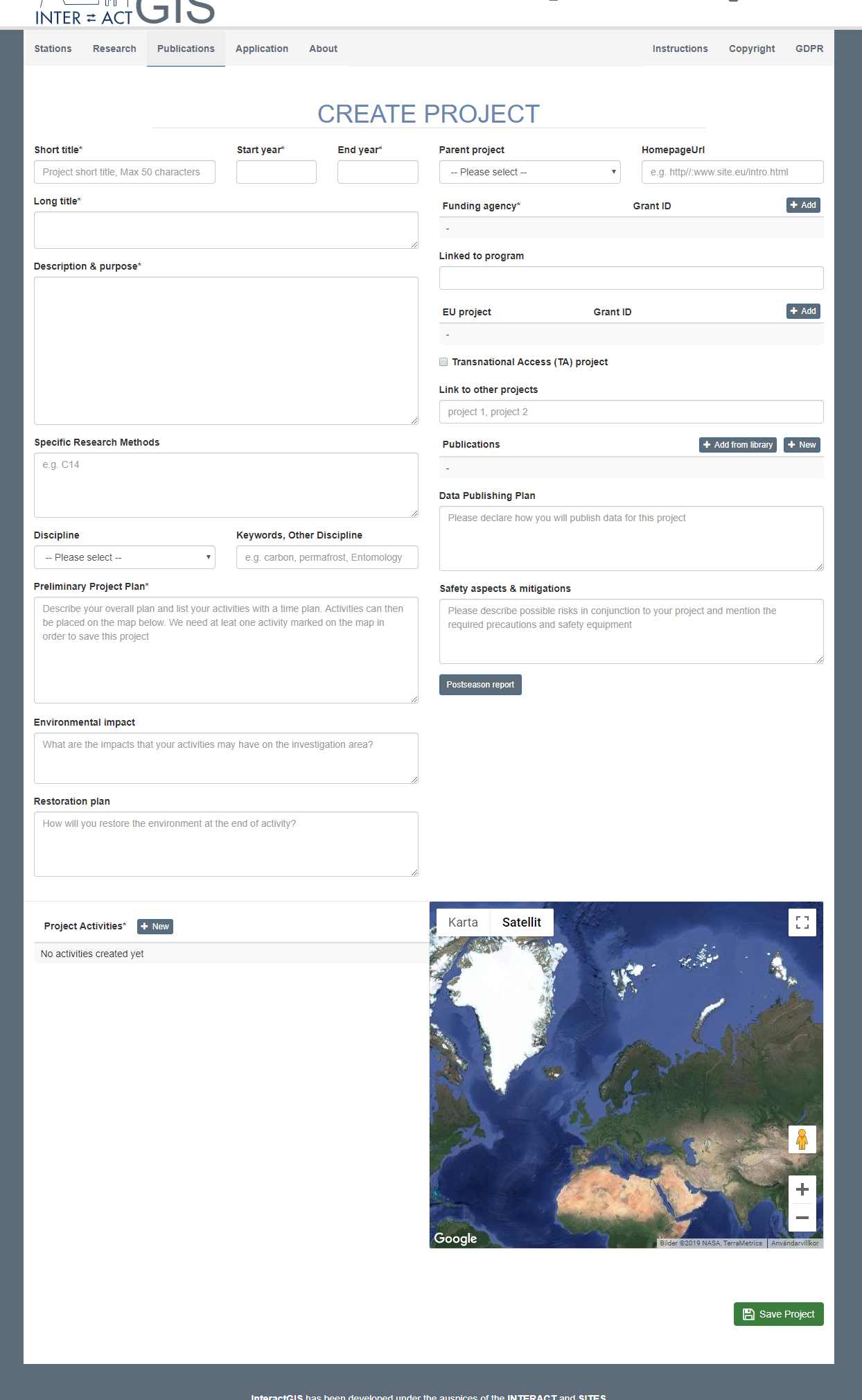
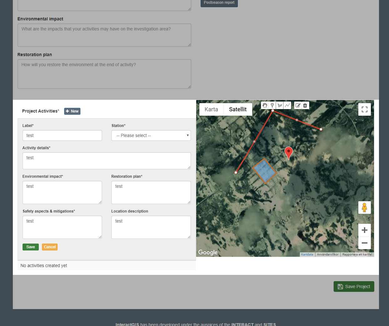
Project Activities
To add a project activities to your project click on the "New" button. Then you can set label, select a station this activity is connected to.
On the google map you can pinpoint where your project activities will be taken place. You can put markers, draw lines and shapes by clicking on
the icons. You can edit the shapes, lines or markers you have already drawn by clicking the pen icon or remove them by clicking on the trashcan.
Remember to save your activities.
The activities have to be confirmed by the station you selected or an application for the project has to be approved in order to see this project in the "Research" page.
If you have two activities on two different station and only one has an approved application, your project will only be listed on that station.
Transnational Access (TA) project
If your project is a TA project, check the checkbox.
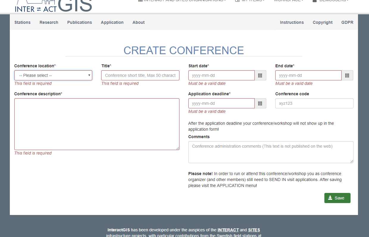
Create a new course or conference
To create a new course/conference you have to access "NEW course/education" or "NEW conference/workshop" in the My items"-menu. The two types of activities contain the same type of information that needs to be filled in.
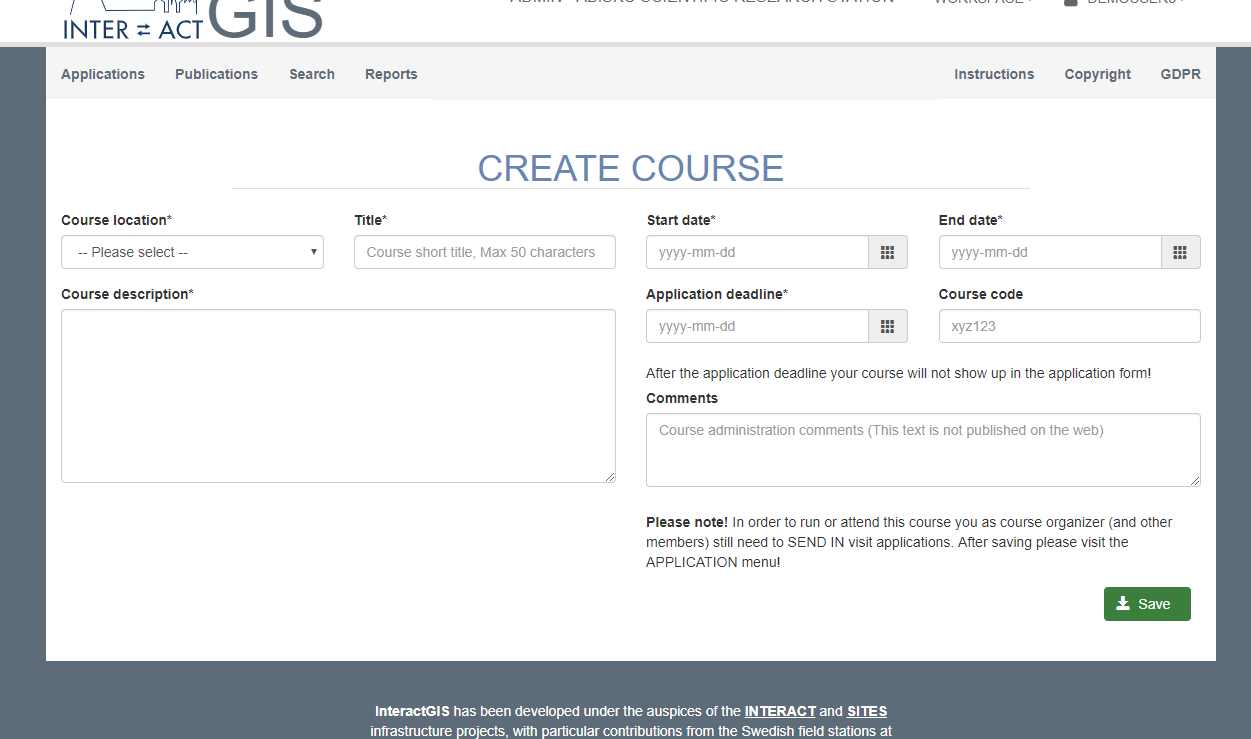
This includes the same required fields, as seen below.