Station Features

Opening year: 1974 Status: Open
  • Type of station: Station
  • Operational period: Continuous
  • Name of station owner: Swedish University of Agricultural Sciences (SLU)
  • Type of owner: University
  • Name of managing institution: Dept. of Ecology
  • Station owner country: Sweden
  • Station latitude: 59,72868000
  • Station longitude: 15,47249000
  • Country (station location): Örebro county
  • Altitude of station: 120 m a.s.l
  • Min. altitude within study area: 85 m a.s.l
  • Max. altitude within study area: 172 m a.s.l
  • Nearest town/settlement: Riddarhyttan
  • Distance to nearest town/settlement: 12 km
  • Distance to nearest public transport facility (Airport, Ferry terminal, Train station, Bus station): 27 km
  • Distance to nearest research station: 228 km
  • Maps available at station: https://www.google.se/maps/place/Sveriges+Lantbruksuniversitet+SLU+Grims%C3%B6+forskningsstation/@59.7280069,15.4697622,17z/data=!3m1!4b1!4m5!3m4!1s0x465dc84e947602cd:0x235930a432044ba2!8m2!3d59.7280042!4d15.4719509
  • Climate zone: Boreal
  • Mean annual temperature: 4,1 °C
  • Mean temperature in February: -5,2 °C
  • Mean temperature in July: 16,3 °C
  • Snow free period (month to month): May-November

Facilities

  • Area under roof: 400 m²
  • Max. number of visitors at a time : 35
  • Showers: Yes
  • Laundry facilities: Yes

Science

  • Transnational Access: No
  • Remote Access: No
  • INTERACT Virtual Access: No
  • Climate
    • Snow
    • Rain
    • Hail
  • Features in the facility area
    • Permanent snowpatches
    • Mountain
    • Valley
    • Lake
    • River
    • Shoreline
    • Tree line
    • Polar deserts/semi-deserts
    • Shrub tundra
    • Gramminoid tundra
    • Forest tundra
    • Peatlands
    • Wetlands
    • Palsa mires
    • Deciduous forest
    • Evergreen forest
    • Human settlements or resource use in the area
    • Arable land
    • Other
  • Main science disciplines
    • Astronomy
    • Atmospheric sciences
    • Cryology
    • Geology
    • Hydrology
    • Limnic biology
    • Marine biology
    • Terrestrial biology
    • Human biology
    • Anthropology
    • Archaeology
    • Sociology
    • Climate change
    • Environmental science (incl. pollution)
    • Oceanography
    • Agriculture
    • Animal husbandry
    • Fisheries
    • Forestry
    • Hunting
    • Tourism
  • Housing and accomodation
    • Showers
    • Laundry facilities
    • A
    • B
    • C
    • D
    • E
    • F
    • G
    • H
    • I
    • J
    • K
    • L
    • M
    • N
    • O
    • Municipal grid
    • Diesel/oil/gas
    • Wood
    • Solar
    • Wind
    • Water
    • Geothermal
    • Biofuel
    • Other
  • Workshop facilities
    • Metal workshop
    • Wood workshop
    • Plexiglas workshop
    • Staff available to assist with constructions
  • Communication
    • Telephone
    • Satellite phone
    • VHF
    • E-mail
    • Internet
    • Computer
    • Printer
    • Scanner
    • Fax
  • Aircraft landing facilities
    • Helipad
  • Permitting issues categories
    • Permits required for studies
    • Permits required for access to the station
  • Meteorology
    • Air temperature
    • Air humidity
    • Air pressure
    • Wind velocity
    • Wind direction
    • Precipitation
  • Energy balance and radiation
    • Energy balance
    • Short wave incoming
    • Short wave outgoing
    • Long wave incoming
    • Long wave outgoing
    • Net radiation
    • UV-B
    • Multi-spectral
    • Cloud cover/hours of sunshine
  • Vegetation
    • Flowering phenology
    • Amount of flowering
    • NDVI (plot/transect)
    • Landscape NDVI (from satellite images)
    • Vascular plant community composition
    • Bryophyte community composition
    • Lichen community composition
    • Fungi community composition
    • Berry production
    • Aerobiological monitoring (pollen, spores, etc.)
    • Species list (community composition)
  • Birds
    • Abundance
    • Distribution
    • Phenology
    • Breeding birds
    • Nest initiation phenology
    • Nest predation rates
    • Species list (community composition)
  • Mammals
    • Mammal abundance
    • Mammal distribution
    • Mammal reproduction
    • Mortality
    • Predation
    • Physiology
    • Species list (community composition)
  • Genetics
    • Collection of genetic material
  • Diseases
    • Mammals
    • Birds
    • Fish
    • Vegetation
    • Other
  • Pollution
    • Pollution measurements in vegetation
    • Pollution measurements in water
    • Pollution measurements in mammals (body burdens, biomarkers)
    • Pollution measurements in birds (body burdens, biomarkers on both adults and offspring e.g. egg shell thinning, macro plastic in nests/in body)
  • Parasites
    • Mammals
    • Birds
    • Fish
    • Vegetation
    • Other

Station name and owner

Location

Climate data

Grey colours are WMO Climate Normals including maximum and minimum values. Blue colours are individual years.

Export to PDF

Climate data for the stations where extracted via Copernicus Climate Data Store, from the global gridded reanalysis product:
ERA5 monthly averaged data on single levels from 1940 to present. Description and source code: Roemer J.K. 2023. https://doi.org/10.5281/zenodo.10214922 Data Source: Hersbach et al. 2023. Copernicus Climate Change Service (C3S) Climate Data Store (CDS), https://doi.org/10.24381/cds.f17050d7

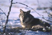
Biodiversity and natural environment

History and facilities

General research and databases

Station Monitoring

Human dimension

Access

Member of: